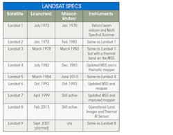
NASA is scheduled to launch Landsat 9 into orbit this September, where it will replace Landsat 7 and join Landsat 8 in providing images of the Earth. It will become the latest imaging satellite to be used in the Landsat program, a partnership between NASA and the U.S. Geological Survey to monitor and record images of the Earth’s surface for use in understanding and managing land resources.
The Landsat program, which put Landsat 1 in orbit in 1972, represents the longest continuous global record of the Earth’s surface; it continues to deliver visually stunning and scientifically valuable images of our planet. Now, with almost 50 years of images from the entire surface of the Earth in the database, scientists and researchers can track tends in such things as changes in shorelines, the growth and decline of forests and glaciers, and pollution.
“The Landsat program was the granddaddy of them all, as far as starting the trend of repetitive, calibrated observations of the Earth at a spatial resolution where one can detect human’s interaction with the environment,” says Darrel Williams, the Landsat 7 project scientist.
Landsat is the only U.S. satellite system designed and operated to repeatedly observe the Earth’s surface at a moderate scale that shows natural and human-caused changes. Maintaining continuous coverage and avoiding a data gap is a high priority for NASA. So, Landsat 9 is similar to Landsat 8, which let NASA quickly build and launch what they are confident will be a capable and reliable imaging platform.
NASA was caught off-guard in 1993 when Landsat 6 exploded just after separating from its Titan II launcher. Martin Marietta, the aerospace firm that built Landsat 6, and the National Oceanic and Atmospheric Administration (NOAA) determined that the explosion was caused by a ruptured hydrazine manifold. They recommended a task force investigate hydrazine feed systems use “safe and failure-free” to use in future Landsat spacecraft.
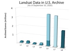
Fortunately, Landsat 5 was a trooper and stayed on the job from 1984 to 2013—29 years, far longer than its design life. In fact, Landsat 5 set a Guinness World Record for Longest Operating Earth Observation Satellite. Over its life, it collected more than 2.8 million images.
In terms of sensor capability, Landsat 9, like its immediate predecessor, will have greater imaging capabilities than previous versions and collect a vast amount of valuable data to be added to the program’s global archive. For reference, Landsat 8 collected data for seven years, which amounted to 1.86 million images—nearly 20% of the total archive. And Landsat 8 adds 700 new images each day.
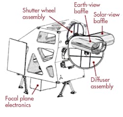
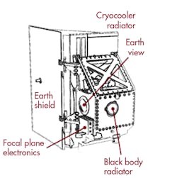
Landsat 9 will carry two imaging instruments: the Operational Land Imager 2 (OLI-2), essentially a copy of the OLI on Landsat 8, and the Thermal Infrared Sensor 2 (TIRS-2), very much like the one on Landsat 8.
The OLI-2, like OLI, provides 14-bit image data, but for the first time all 14 bits will be retained and transmitted to the ground. The focal plane modules on OLI-2 were flight spares for OLI and will be retested by Ball Aerospace & Technologies Co., the company that built it, before the launch. The device captures images in the visible, near IR, and short-wave IR spectrum. Its images have 15-m (49 ft.) panchromatic and 30-m multi-spectral spatial resolutions along a 185 km (115 miles) wide swath, collecting images of the Earth with enough resolution to pick out features such as urban centers, farms, forests and shorelines.
The TIRS on Landsat 8 was a class C instrument, giving it a three-year design lifetime with limited redundancy. TIRS-2 on the newer satellite, however, will be a class B instrument with a five-year design lifetime like the OLI-2. TIRS-2 will measure the thermal IR radiation, or heat (brightness temperature), of Earth’s surfaces.

