NASA’s OCO-2 satellite will monitor CO2 on Earth
This file type includes high-resolution graphics and schematics when applicable.
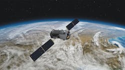
To get a better idea of where CO2 is emitted and absorbed on Earth, scientists and engineers at NASA have rebuilt the OCO (Orbiting Carbon Observatory) that was lost on launch in February 2009 due to a failure of the payload fairing. The new satellite, the OCO-2, is scheduled to be sent into orbit July 1 of this year from Vandenberg Air Force Base in California. To save money and stay on schedule, NASA was directed “to duplicate the original OCO design using identical hardware, drawings, documents, procedures, and software wherever possible and practical.”
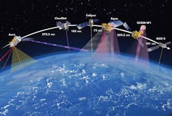
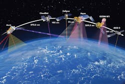
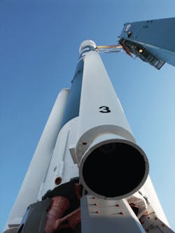
But there will be at least one change. A Delta II rocket rather than a Taurus rocket will transport the OCO-2 into its initial orbit 395 miles above the Earth. The satellite will then fire its four hydrazine-fueled thrusters to take it up and maneuver into position at the head of the A-Train (see Here comes the A-Train) in a sun-synchronous polar orbit 438 miles above the Earth. The spacecraft will circle the Earth every 98.8 min, crossing the equator at 13:15 (local time), and repeat its pattern every 16 days, letting it cover the entire surface of the Earth.
The spacecraft’s thrusters will use what’s left of the 99 lb of hydrazine to maintain OCO-2’s position leading the A Train over the course of its two-year mission while saving some fuel to deorbit at the end of its usefulness.
The Spacecraft
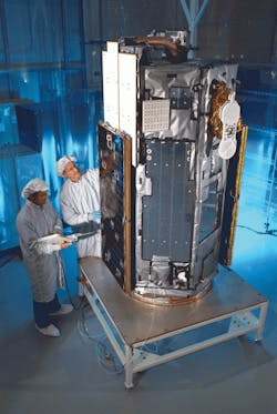
OCO-2 is built on a LEOStar-2 platform from Orbital Sciences Corp., Dulles, Va. LEOStar-2 was originally designed 10 years ago to be launched from Pegasus XL, an air-launched, winged spacecraft, but it is now routinely sent aloft on Taurus, Minotaur, and Delta rockets as well. It can be used for small-to-medium payloads and hardware weighing up to 1,100 lb. OCO-2 weighs about 990 lb. The platform has successfully served as the basic structure for several satellites, including the NuStar satellite currently taking X-ray images of the stars and the Galex satellite that took UV images of roughly 1 million galaxies.
LEOStar comes with avionics capable of delivering 2 kW of average power. The version housing the OCO-2 will carry a pair of triple-junction GaAs solar panels 10-ft long that generate 900 W when deployed and in sunlight. NASA estimates the craft will consume 521 W on average when operational. The panels charge a 35-A-hr nickel-hydrogen battery for backup power when the satellite is shaded.
LEOStar also provides hardware for precisely pointing the OCO-2 telescope at Earth. A set of four reaction wheels from Goody/Ithaco control the craft’s pitch, roll, and yaw, and a trio of magnetic torque rods despin the wheels when needed. And although a GPS unit provides orbital positioning, it uses a star tracker, miniature inertial measurement unit, and a magnetometer to accurately determine and maintain the necessary pointing position or attitude for OCO-2’s telescope.
For communications, the LEOStar is outfitted with X and S-band transmitters, receivers, and antennae. Data the spacecraft collects, along with information on the satellite itself, can be quickly transmitted to the Earth on the X band at 150 Mbits/sec. And while the S-band equipment can be used for data, it can also used to uplink new missions and instructions from NASA.
The Sensor
OCO-2 houses only one instrument and it does not actually directly measure CO2. Instead, it measures the intensity of the sunlight reflected from CO2 in a column of air.
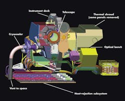
In operation, the instrument takes light coming in through a telescope and splits it into three identical beams. The light has traveled through the atmosphere twice — once on its way to Earth, and again as it makes its way to the OCO-2. Along the way, some of the light at specific wavelengths from the sun is absorbed by atmospheric CO2 and O2 and won’t make it to the OCO-2. The spacecraft determines how much CO2 and O2 are in a column of air based on how much light diminished at those wavelengths.
Each of the three beam bounces off a different diffraction grating, a series of regularly spaced grooves on a flat surface which breaks the light down into its constituents, much like a CD reflects white light into various colors. In the OCO-2, gratings break light down so that the sensor can measure the intensity in three narrow bands centered on 1.61, 0.76, and 2.06-µm wavelengths. The 1.06-µm band is most sensitive to CO2 concentrations near the Earth’s surface. Other atmospheric gases absorb energy in this spectral range, so measurements are clear and unambiguous. Another grating concentrates on the 2.06-µm band, which should give clear evidence of the amount of CO2 in the air.
Here comes the A-TrainThe A-Train is one of NASA’s more innovative, if inadvertent, approaches to studying the Earth and its atmosphere. It’s a conga line of Earth-observing satellites all in the same polar orbit and looking at different aspects of the same swath of land, sea, and air. They use technologies that go from UV to microwave, a wavelength span of four orders of magnitude. Plus, all the daily readings are taken within 14 min of each other, so scientists and others studying the data can correlate one satellite’s data with another’s. The line of satellites crosses the equator at around 1:20 p.m., which is how it got its name: the A(fternoon) Train. From front to back, the train consists of: The Train got started accidently and represents a space-flight first: formation flying. When NASA was trying to choose a good orbit for Aura in 2004, they decided just to copy the orbit they used for Aqua, a sister spacecraft launched in 2002. Limitations in data-transmission rates, however, forced NASA to fly the new satellite much closer to the Aqua than they had planned, about 4,000 miles, or 15 min, behind the older spacecraft at the time. Then in 2006, the operators of two satellites that would measure and map airborne aerosols and clouds — Calipso and CloudSat — each requested identical orbits near Aqua because they both wanted to correlate their data with the humidity and cloud measurements from Aqua. So Calipso and CloudSat jumped on the train right behind Aqua. At least one spacecraft has climbed aboard then gotten off the A-Train. The French Space Agency’s Parasol (Polarization and Anisotropy of Reflectances for Atmospheric Sciences coupled with Observations from a Lidar) spent five years tucked in between CloudSat and Aura taking measurements. By 2009, however, it had run short of fuel, so it gracefully fell out of formation and dropped to an orbit that was initially 2.4 miles beneath that of the A-Train. This let its data periodically overlap data from A-Train members as its orbit has decayed. It eventually ceased operating and fell to Earth in 2013. |
But the instrument also needs reading on a reference gas, one uniformly distributed throughout the atmosphere. That’s why the instrument looks at oxygen in the 0.76-µm band. Readings will give an indication of how much cloud cover there is and whether there are localized concentrations of aerosols. It will also be used to infer the total atmospheric pressure and the length of the path that light took passing though the atmosphere on its way to OCO-2.
To ensure spectrometer readings are accurate, the light detectors — focal plane arrays — are kept at –184°F by a cryocooler. This prevents energy from other sources contaminating the readings.
In another bid for accuracy, the satellite will be taking readings of reflected sunlight when the sun is high in the sky. This will maximize the signal-to-noise ratio. Its reading will also occur when the amount of CO2 in the air is at its daily average.
The multispectrometer has three modes: Nadir, Glint, and Target. In Nadir, the telescope looks straight down at the Earth along the satellite’s ground path. It is expected to generate accurate returns in mountainous areas and those covered by partial clouds. However, it may be useless over dark ocean surfaces due to its low signal-to-noise ratio.
In Glint mode, the telescope points to the where sunlight reflects off the Earth’s surface, usually off of water. These reading can be 100 times as bright as those in Nadir, so the signal-to-noise ratio is much higher. The current plan is to spend one 16-day cycle mapping in Nadir, then the next cycle mapping in Glint. This ensures the entire surface of the Earth gets mapped in both roughly every month.
Target mode locks the telescope on a specific piece area on the Earth and takes readings constantly as the satellite passes overhead. It lets the sensor take up to 12,960 samples at angles that vary from 0 to 85°.
